
Turn on suggestions
Auto-suggest helps you quickly narrow down your search results by suggesting possible matches as you type.
Showing results for
Turn on suggestions
Auto-suggest helps you quickly narrow down your search results by suggesting possible matches as you type.
Showing results for
Community Tip - New to the community? Learn how to post a question and get help from PTC and industry experts! X
Options
- Subscribe to RSS Feed
- Mark Topic as New
- Mark Topic as Read
- Float this Topic for Current User
- Bookmark
- Subscribe
- Mute
- Printer Friendly Page
Can you finish the Mathcad 15 sheet in attach?
Nov 10, 2015
10:10 AM
- Mark as New
- Bookmark
- Subscribe
- Mute
- Subscribe to RSS Feed
- Permalink
- Notify Moderator
Nov 10, 2015
10:10 AM
Can you finish the Mathcad 15 sheet in attach?
I would like to create the web-sheet for calculation S and L between two place on Earth with geo coordinate.
Finish please the sheet in attach!
Labels:
- Labels:
-
Other
15 REPLIES 15
Nov 10, 2015
10:42 AM
- Mark as New
- Bookmark
- Subscribe
- Mute
- Subscribe to RSS Feed
- Permalink
- Notify Moderator
Nov 10, 2015
10:42 AM
I think you'll find the information you need here: https://en.wikipedia.org/wiki/Great-circle_distance#Formulas
Nov 10, 2015
08:00 PM
- Mark as New
- Bookmark
- Subscribe
- Mute
- Subscribe to RSS Feed
- Permalink
- Notify Moderator
Nov 10, 2015
08:00 PM
Thanks, Mark.
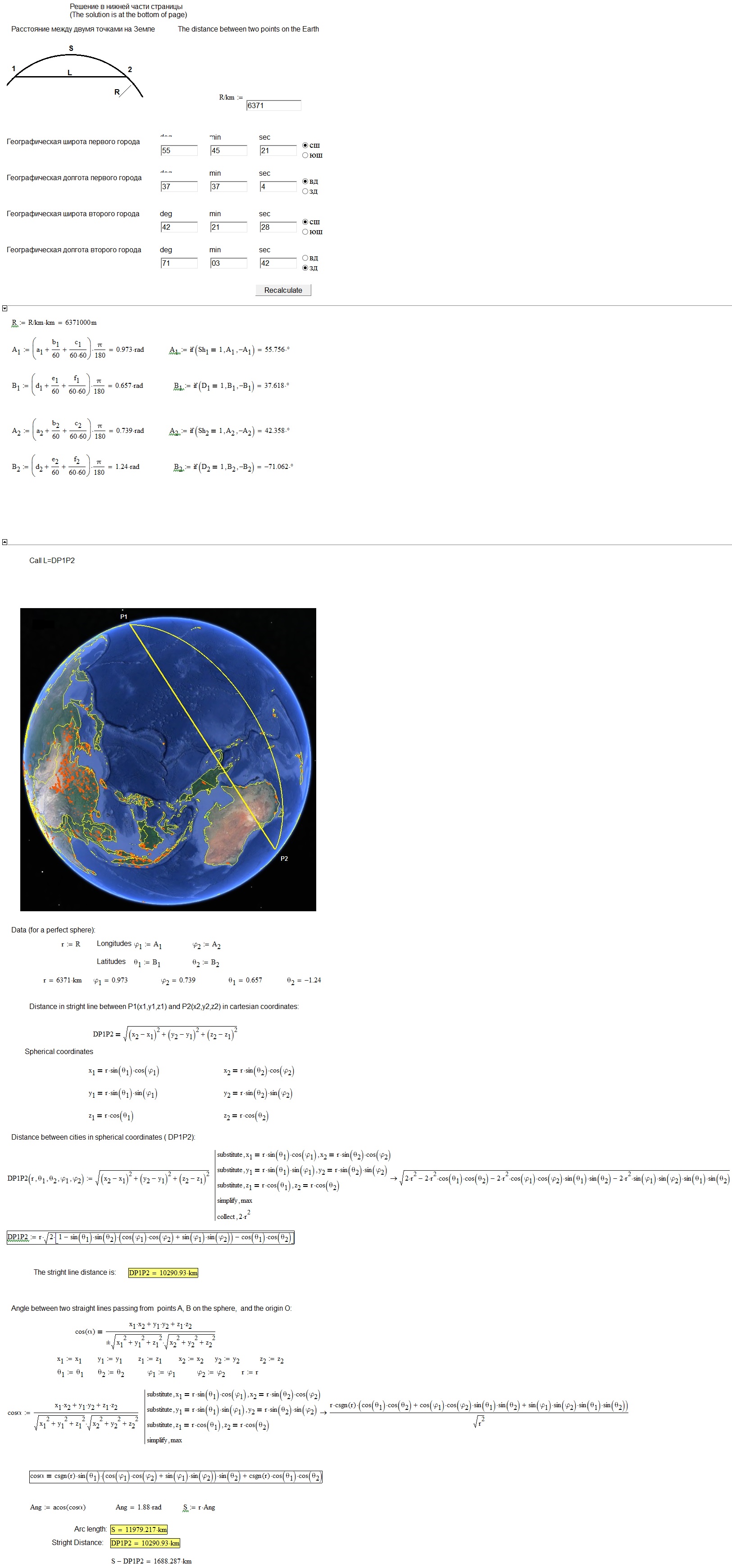
It is a subproblem for this problem - http://twt.mpei.ac.ru/ochkov/SPB-Moscow-Train.pdf
There is one online calculator Online calculator: Course angles and distance between the two point on the orthodrome(great circle)
But my dada is open web online calculations with Mathcad (MAS and MCS) with view all formulas and Intermediate results.
Dec 20, 2015
06:26 AM
- Mark as New
- Bookmark
- Subscribe
- Mute
- Subscribe to RSS Feed
- Permalink
- Notify Moderator
Dec 20, 2015
06:26 AM
Hello Valery Ochkov!
Do you think, my reply is satisfactory?
Let me know, so also will attach the worksheet.
Greetings Franc.
Dec 20, 2015
07:02 AM
- Mark as New
- Bookmark
- Subscribe
- Mute
- Subscribe to RSS Feed
- Permalink
- Notify Moderator
Dec 20, 2015
07:02 AM
Thanks, Franc.
See please the solution from my students.
http://twt.mpei.ac.ru/MCS/Worksheets/Earth-D-L.xmcd
Is it correct?
-Val
Dec 20, 2015
07:42 AM
- Mark as New
- Bookmark
- Subscribe
- Mute
- Subscribe to RSS Feed
- Permalink
- Notify Moderator
Dec 20, 2015
07:42 AM
First question.
What kind of animal is that?
It's green, it lives at a depth of 2 m and feeds on stones!
The answer - a green stoneeater.
Second question.
What happens if through the center of the Earth to dig a tunnel and throw a stone in the tunnel?
The answer is - a green stoneeater will eat this stone at a depth of 2 meters.
Dec 20, 2015
08:22 AM
- Mark as New
- Bookmark
- Subscribe
- Mute
- Subscribe to RSS Feed
- Permalink
- Notify Moderator
Dec 20, 2015
08:22 AM
Excuse me, I'm a retired teacher from 2011. Of the students I have balls full ... so, please do not talk about students ...
Will be for another time.
Greetings Franc.
Dec 20, 2015
09:10 AM
- Mark as New
- Bookmark
- Subscribe
- Mute
- Subscribe to RSS Feed
- Permalink
- Notify Moderator
Dec 20, 2015
09:10 AM
F.M. написал(а):
Excuse me, I'm a retired teacher from 2011. Of the students I have balls full ... so, please do not talk about students ...
Will be for another time.
Greetings Franc.
Sorry - is the calculations wrong?
Dec 20, 2015
10:06 AM
- Mark as New
- Bookmark
- Subscribe
- Mute
- Subscribe to RSS Feed
- Permalink
- Notify Moderator
Dec 20, 2015
10:06 AM
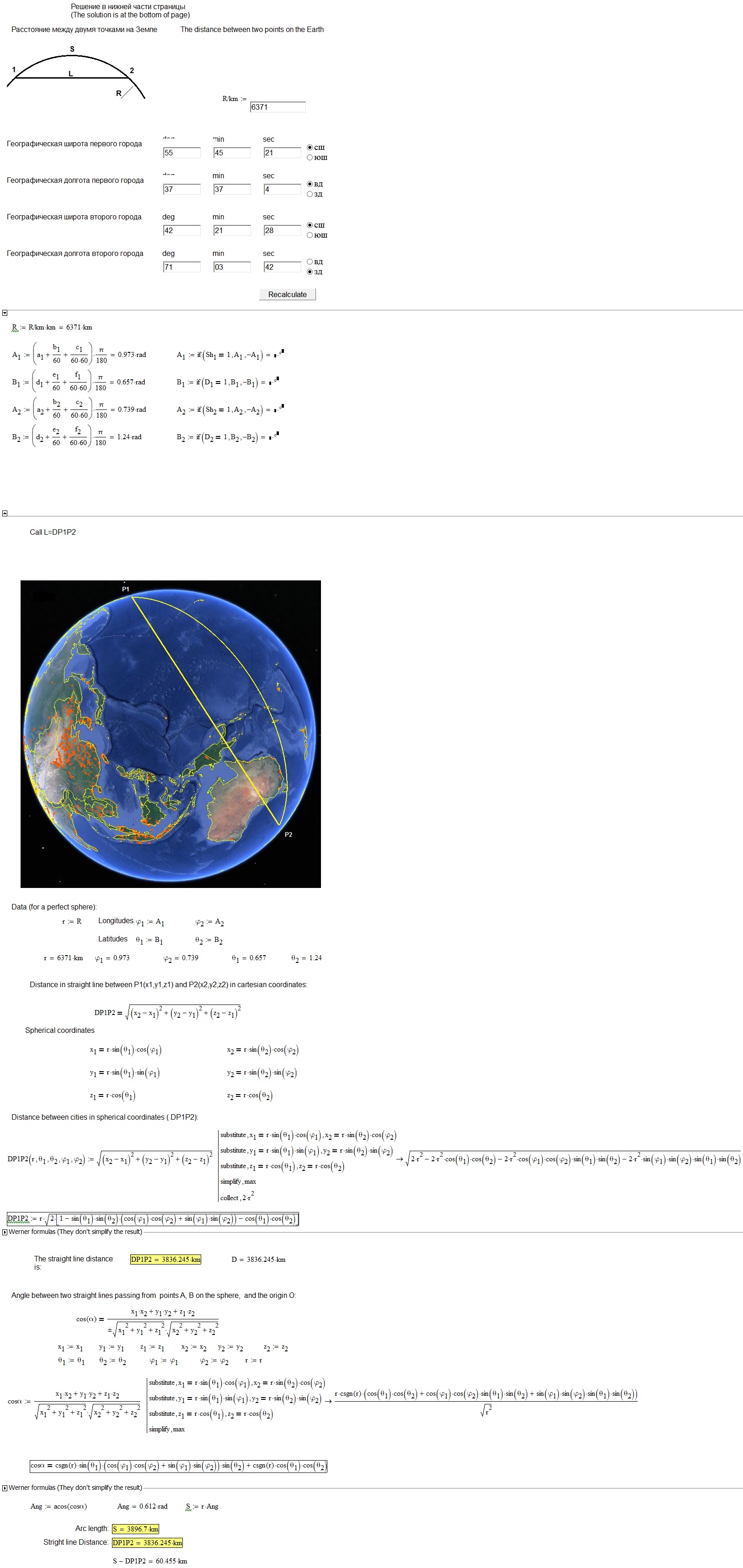
I see that the results are different from mine. Maybe there are different data.
(indeed there is something wrong in the data. I do not know the Russian language.)
Deactivating the definition in degrees of latitude and longitude and measuring them in radians, I get:
Dec 20, 2015
08:59 PM
- Mark as New
- Bookmark
- Subscribe
- Mute
- Subscribe to RSS Feed
- Permalink
- Notify Moderator
Dec 20, 2015
08:59 PM
I maybe wrong and maybe I am missing the point, but isn't this a fairly easy task?
Using just those three formulas:
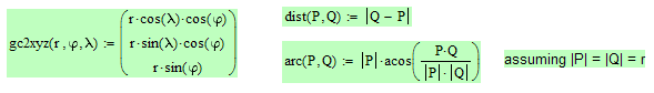
I can't check your students sheet as its not available anymore, but for the distance on the orthodrome at least I get the very same result as the site you try to duplicate.
To perfectly duplicate the values this site gives back when you choose "ball" you have to set the earth radius to 6378.137 km as this seems to be the value used at that site. Its not the mean value usually taken to make a sphere the same volume as the geoid but this value is the radius at the equator according to the ellipsoid GRS 80 resp. WGS84 from the year 1979.
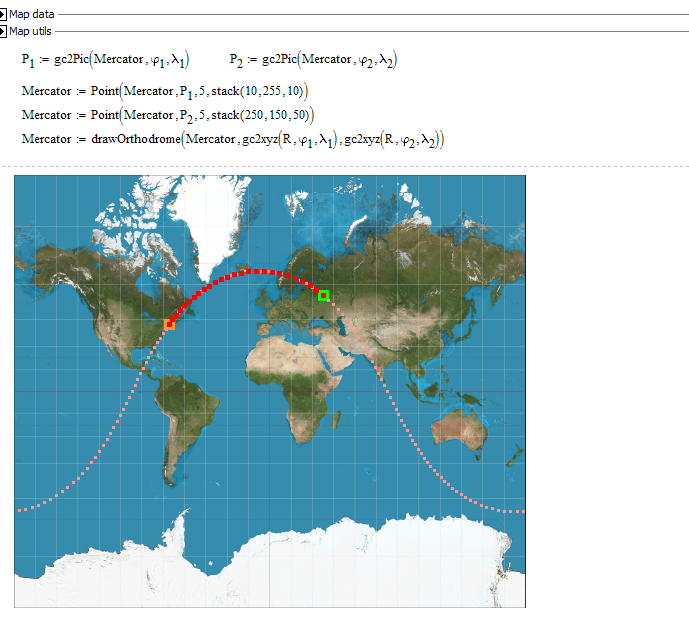
In the map below I also draw the orthodrome of the two points, the great circle they are lying on. Of course it does not appear as a straight line in the Mercator map.
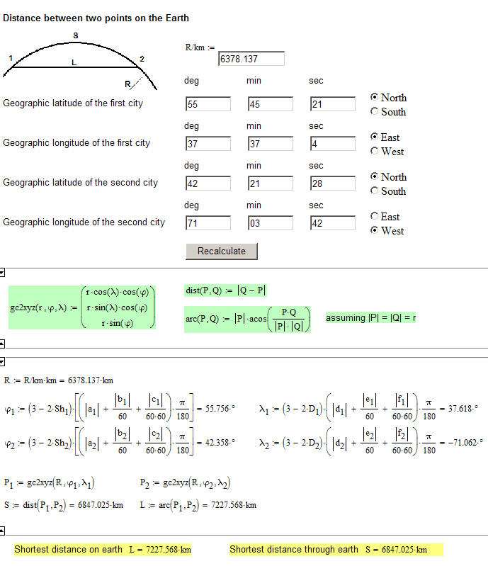
Regards, Werner
Dec 21, 2015
09:13 AM
- Mark as New
- Bookmark
- Subscribe
- Mute
- Subscribe to RSS Feed
- Permalink
- Notify Moderator
Dec 21, 2015
09:13 AM
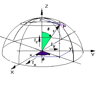
Sorry to return again on the subject. I want to clarify that the angles by me used (latitude and longitude) are those commonly used in analysis, geometry and electromagnetism and illustrated in octant here depicted below. Certainly I have not referred to the conventions of the art navigation or similar. (The z axis coincides with the terrestrial axis.)
Bye
Dec 21, 2015
12:03 PM
- Mark as New
- Bookmark
- Subscribe
- Mute
- Subscribe to RSS Feed
- Permalink
- Notify Moderator
Dec 21, 2015
12:03 PM
You didn't use geographical coordinates as needed, so this explains the wrong results you got.
It furthermore explains your confusion about the North-South, East-West selectors, which you unfortunately had disabled in your last version. I don't know any Russian at either all but the meaning was clear from the context if you think of geographical coordinates - those selectors had to be there (and they are, too, on the site, Valery had linked to and which he is trying to imitate) . They do not do any harm - they just change the sign if needed (if South or West is selected) and have nothing to do with degree vs. radian. Valery just displayed the results in degrees (which makes much sense in this context).
So I guess your picture of the earth is just a static one and is not dynamically showing the entered locations as the Mercator plot does finally (this was the main work and its still unsatisfactory).
I was not able to find a decent set of continent border data to make a 3D earth plot showing the locations and connections. Maybe some day when I am really bored I'll download a set of KML data and extract the coordinates - but then, probably not.
Werner
Dec 21, 2015
01:24 PM
- Mark as New
- Bookmark
- Subscribe
- Mute
- Subscribe to RSS Feed
- Permalink
- Notify Moderator
Dec 21, 2015
01:24 PM
Thank you, Werner for your kind response. Certainly, I have considered the angles in radians, already present in the worksheet of Valery. My graphics, no claim, they are sketches made with Paint. The verification of the measurement of distances can be done with "Google Earth", I'm sure you certainly know (here, in my country, it is very common) and from which I have drawn the image of the globe with a simple keyboard print. What I mind is the correctness of the calculations resulting from geometrical considerations in space. Not knowing the Russian language, I tried to translate with google translator the fundamental astronomical four directions north south east west, associated with the radio button, but I did not find the correspondence, even with abbreviations. I had guessed, but I preferred to proceed. The answers that I generally do, are the proofs that need, as such, more and corrections. But I think that, since it's only recently that I try to participate in discussions it happens that, as you know, when something starts, the output can have a transitory with "ups and downs" dangerous, which then dampen. It would not be wise, for me, to continue down this road.
Merry Christmas
With best regards
F. M.
Dec 21, 2015
07:51 PM
- Mark as New
- Bookmark
- Subscribe
- Mute
- Subscribe to RSS Feed
- Permalink
- Notify Moderator
Dec 21, 2015
07:51 PM
I used Google translator, too, and also could not find those abbreviations 😉 But it had to be the directions as it deals with geographical coordinates (and of course I looked at the calculation page Valery referred to. Shame on Valery for not providing an English sheet.
But I think that, since it's only recently that I try to participate in discussions it happens that, as you know, when something starts, the output can have a transitory with "ups and downs" dangerous, which then dampen. It would not be wise, for me, to continue down this road
I think I don't understand the meaning of those lines!?
All the best to you, too
Werner
Dec 21, 2015
02:01 PM
- Mark as New
- Bookmark
- Subscribe
- Mute
- Subscribe to RSS Feed
- Permalink
- Notify Moderator
Dec 21, 2015
02:01 PM
Werner Exinger написал(а):
...East-West selector...
Werner
The Greenwich meridian Prime meridian - Wikipedia, the free encyclopedia
(Foots and photo by Valery Ochkov)

Dec 21, 2015
01:48 PM
- Mark as New
- Bookmark
- Subscribe
- Mute
- Subscribe to RSS Feed
- Permalink
- Notify Moderator
Dec 21, 2015
01:48 PM
Read: not octant but hemisphere.

