Turn on suggestions
Auto-suggest helps you quickly narrow down your search results by suggesting possible matches as you type.
Showing results for
Please log in to access translation
Turn on suggestions
Auto-suggest helps you quickly narrow down your search results by suggesting possible matches as you type.
Showing results for
- Community
- ThingWorx
- ThingWorx Developers
- How to solve the NaN value in updated location fie...
Translate the entire conversation x
Please log in to access translation
Options
- Subscribe to RSS Feed
- Mark Topic as New
- Mark Topic as Read
- Float this Topic for Current User
- Bookmark
- Subscribe
- Mute
- Printer Friendly Page
How to solve the NaN value in updated location field
May 18, 2017
09:59 PM
- Mark as New
- Bookmark
- Subscribe
- Mute
- Subscribe to RSS Feed
- Permalink
- Notify Moderator
Please log in to access translation
May 18, 2017
09:59 PM
How to solve the NaN value in updated location field
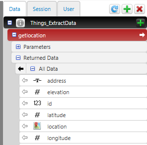
My code is to get a new field of location from available column longitude, latitude, elevation. Built with no error.
// result: INFOTABLE  dataShapeName : "MapData"
var result = Things["ThingName"].ServiceName(); // Change the ThingName and Service name herevar newField = new Object();
newField.name = "location";
newField.baseType = 'LOCATION';
result.AddField(newField);// location:LOCATION
var temp = new Object();var tableLength = result.rows.length;
for (var x = 0; x < tableLength; x++) {
    var row = result.rows;
    temp.latitude = row.latitude;//result.rows.latitude;
    temp.longitude = row.longitude;//result.rows.longitude;
    temp.elevation = 0;
    temp.units = "WGS84";
    row.location = temp;
}
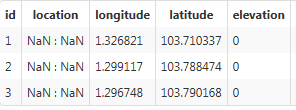
But the output is like this. The location column is all NaN:NaN. Something is wrong?
Solved! Go to Solution.
Labels:
- Labels:
-
Coding
-
Troubleshooting
ACCEPTED SOLUTION
Accepted Solutions
May 19, 2017
05:37 AM
- Mark as New
- Bookmark
- Subscribe
- Mute
- Subscribe to RSS Feed
- Permalink
- Notify Moderator
Please log in to access translation
May 19, 2017
05:37 AM
The "result" in my test is a new InfoTable of DataShape NamedVTQ, created directly in service. Then I added 10 rows with only "value" before adding the new field "location". The "latitude" and "longitude" are just 0,1,2...
var data = Resources["InfoTableFunctions"].CreateInfoTableFromDataShape({dataShapeName: "NamedVTQ"});
for (var i = 0; i < 10; i++) {
data.AddRow({name: "name_" + i}) ;
}
var newField = new Object();
newField.name = "mylocation";
newField.baseType = 'LOCATION';
data.AddField(newField);
var tableLength = data.length;
for (var x = 0; x < 10; x++) {
var row = data
; var tmp = new Object();
tmp.latitude = x;
tmp.longitude = x * 10;/
tmp.elevation = 0;
tmp.units = "WGS84";
// 3 rows below work
// data
.mylocation = tmp; // data.rows
.mylocation = tmp; row.mylocation = tmp;
data.AddRow({mylocation: tmp, value: tmp.latitude});
data
.value = tmp.latitude; }
data.AddRow({mylocation: tmp, name: "name_99", value: 99});
logger.debug(data.rows);
result = data;
13 REPLIES 13
May 19, 2017
04:37 AM
- Mark as New
- Bookmark
- Subscribe
- Mute
- Subscribe to RSS Feed
- Permalink
- Notify Moderator
Please log in to access translation
May 19, 2017
04:37 AM
Pleas move
var temp = new Object();
inside for loop
other wise you are setting all the location field to one object and do the change on one object
Thanks
YUanwu Shen
May 19, 2017
05:59 AM
- Mark as New
- Bookmark
- Subscribe
- Mute
- Subscribe to RSS Feed
- Permalink
- Notify Moderator
Please log in to access translation
May 19, 2017
05:59 AM
My code is like this now:
var tableLength = result.rows.length;
for (var x = 0; x < tableLength; x++) {
var row = result.rows
; var temp = new Object();
temp.baseType = 'LOCATION';
temp.latitude = row.latitude;
temp.longitude = row.longitude;
temp.elevation = 0;
temp.units = "WGS84";
result.rows
.location = temp; }
My output still the same...
May 19, 2017
10:03 PM
- Mark as New
- Bookmark
- Subscribe
- Mute
- Subscribe to RSS Feed
- Permalink
- Notify Moderator
Please log in to access translation
May 19, 2017
10:03 PM
Dear Yuan Wu,
Thanks for your help. Please see my latest update. There is new problem in the google map... Maybe the precision of the digits in the location?
May 19, 2017
04:47 AM
- Mark as New
- Bookmark
- Subscribe
- Mute
- Subscribe to RSS Feed
- Permalink
- Notify Moderator
Please log in to access translation
May 19, 2017
04:47 AM
May 19, 2017
06:00 AM
- Mark as New
- Bookmark
- Subscribe
- Mute
- Subscribe to RSS Feed
- Permalink
- Notify Moderator
Please log in to access translation
May 19, 2017
06:00 AM
In the loop script,
var row = result.rows
So I think the code is right.
May 19, 2017
05:11 AM
- Mark as New
- Bookmark
- Subscribe
- Mute
- Subscribe to RSS Feed
- Permalink
- Notify Moderator
Please log in to access translation
May 19, 2017
05:11 AM
Hello,
The behavior is weird. Before the end of for loop, if I add "result.AddRow({location: temp}), the new rows are added with correct location. When I log the result, the data structure is different too.
"location" where is Nan: "location={"elevation":1.0,"latitude":1.0,"units":"WGS84","longitude":0.0}"
Correct "location" added at the end of result: "location=1.0,1.0,0.0"
May 19, 2017
05:33 AM
- Mark as New
- Bookmark
- Subscribe
- Mute
- Subscribe to RSS Feed
- Permalink
- Notify Moderator
Please log in to access translation
May 19, 2017
05:33 AM
That's Strange because it works fine for me.
The only difference is I am not using the DataBase. My data is stored in a DataTable.
May 19, 2017
05:37 AM
- Mark as New
- Bookmark
- Subscribe
- Mute
- Subscribe to RSS Feed
- Permalink
- Notify Moderator
Please log in to access translation
May 19, 2017
05:37 AM
The "result" in my test is a new InfoTable of DataShape NamedVTQ, created directly in service. Then I added 10 rows with only "value" before adding the new field "location". The "latitude" and "longitude" are just 0,1,2...
var data = Resources["InfoTableFunctions"].CreateInfoTableFromDataShape({dataShapeName: "NamedVTQ"});
for (var i = 0; i < 10; i++) {
data.AddRow({name: "name_" + i}) ;
}
var newField = new Object();
newField.name = "mylocation";
newField.baseType = 'LOCATION';
data.AddField(newField);
var tableLength = data.length;
for (var x = 0; x < 10; x++) {
var row = data
; var tmp = new Object();
tmp.latitude = x;
tmp.longitude = x * 10;/
tmp.elevation = 0;
tmp.units = "WGS84";
// 3 rows below work
// data
.mylocation = tmp; // data.rows
.mylocation = tmp; row.mylocation = tmp;
data.AddRow({mylocation: tmp, value: tmp.latitude});
data
.value = tmp.latitude; }
data.AddRow({mylocation: tmp, name: "name_99", value: 99});
logger.debug(data.rows);
result = data;
May 19, 2017
06:04 AM
- Mark as New
- Bookmark
- Subscribe
- Mute
- Subscribe to RSS Feed
- Permalink
- Notify Moderator
Please log in to access translation
May 19, 2017
06:04 AM
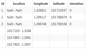
Yes. If I add the a new row,
var tableLength = result.rows.length;
for (var x = 0; x < tableLength; x++) {
    var row = result.rows;
    var temp = new Object();
 temp.baseType = 'LOCATION';

    temp.latitude = row.latitude;
    temp.longitude = row.longitude;
    temp.elevation = 0;
    temp.units = "WGS84";
    result.rows.location = temp;

    result.AddRow({location: temp});}
The result is right then:
May 19, 2017
05:55 AM
- Mark as New
- Bookmark
- Subscribe
- Mute
- Subscribe to RSS Feed
- Permalink
- Notify Moderator
Please log in to access translation
May 19, 2017
05:55 AM
Hi Tiantian Guo,
Based on Quang input; I have following suggestion:
1. Create a new DataShape which has all the fields you require + location field. DataShape1
2. In custom Service create a new Infotable using above DataShape.
var params = {
infoTableName: "INFOTABLE" /* STRING */,
dataShapeName: "DataShape1" /* DATASHAPENAME */
};
// result: INFOTABLE
var result = Resources["InfoTableFunctions"].CreateInfoTableFromDataShape(params);
3. Loop though the old infotable (let's say result1) and Add the Row to the new infotable (result).
var tableLength = result1.rows.length;
for (var x = 0; x < tableLength; x++) {
var temp = new Object();
temp.elevation = 0;
temp.units = "WGS84";
temp.latitude = result1.rows
.latitude; temp.longitude = result1.rows
.longitude; var temp1 = new Object();
temp1.latitude = result1.rows
.latitude; temp1.longitude = result1.rows
.longitude; temp1.location = temp;
result.AddRow(temp1);
}
I hope it helps.
May 19, 2017
10:00 PM
- Mark as New
- Bookmark
- Subscribe
- Mute
- Subscribe to RSS Feed
- Permalink
- Notify Moderator
Please log in to access translation
May 19, 2017
10:00 PM
Dear Ankit,
I got the right result using your code.
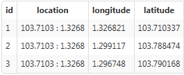
And I attach the result to the google map,
There are nothing appearing.

I thought maybe the precision of the location, there are lacking two digits from the original latitude and longitude..
May 21, 2017
11:26 PM
- Mark as New
- Bookmark
- Subscribe
- Mute
- Subscribe to RSS Feed
- Permalink
- Notify Moderator
Please log in to access translation
May 21, 2017
11:26 PM
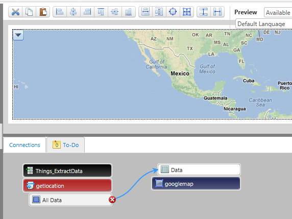
Hi Tiantian Guo,
Could you please start a new Thread for this issue and add a Screenshot of Google widget properties.
Have you selected the location column for location property in Google widget?
May 22, 2017
12:56 AM
- Mark as New
- Bookmark
- Subscribe
- Mute
- Subscribe to RSS Feed
- Permalink
- Notify Moderator
Please log in to access translation
May 22, 2017
12:56 AM
Dear Ankit,
I have selected the location column for location property.