
Turn on suggestions
Auto-suggest helps you quickly narrow down your search results by suggesting possible matches as you type.
Showing results for
Please log in to access translation
Turn on suggestions
Auto-suggest helps you quickly narrow down your search results by suggesting possible matches as you type.
Showing results for
- Community
- ThingWorx
- ThingWorx Developers
- Re: How to display a path(from origin to destinati...
Translate the entire conversation x
Please log in to access translation
Options
- Subscribe to RSS Feed
- Mark Topic as New
- Mark Topic as Read
- Float this Topic for Current User
- Bookmark
- Subscribe
- Mute
- Printer Friendly Page
How to display a path(from origin to destination) of the gps location of a moving android device
Aug 26, 2016
01:00 AM
- Mark as New
- Bookmark
- Subscribe
- Mute
- Subscribe to RSS Feed
- Permalink
- Notify Moderator
Please log in to access translation
Aug 26, 2016
01:00 AM
How to display a path(from origin to destination) of the gps location of a moving android device
I am able to display the changing location of an android device but I can't keep a track of the path from previous to next location.
Labels:
- Labels:
-
Extensions
9 REPLIES 9
Aug 26, 2016
01:41 AM
- Mark as New
- Bookmark
- Subscribe
- Mute
- Subscribe to RSS Feed
- Permalink
- Notify Moderator
Please log in to access translation
Aug 26, 2016
01:41 AM
Hi Priyanshi, i am assuming you are attempting to show path between two markers on Google Map Widget, is this correct? Google Map Widget has a property called ShowPathBetweenMarkers - trythe Google Map Widget doc for more detail.
Let us know if you have something different in mind.
Aug 26, 2016
01:54 AM
- Mark as New
- Bookmark
- Subscribe
- Mute
- Subscribe to RSS Feed
- Permalink
- Notify Moderator
Please log in to access translation
Aug 26, 2016
01:54 AM
I have enabled this marker for google map widget,still it is not showing.I want to show the complete track from origin to next destination till the path ends.
Aug 26, 2016
03:02 AM
- Mark as New
- Bookmark
- Subscribe
- Mute
- Subscribe to RSS Feed
- Permalink
- Notify Moderator
Please log in to access translation
Aug 26, 2016
03:02 AM
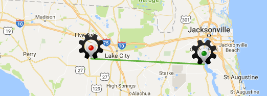
Do you mean something like this? I can log the path using the same property as I mentioned above - hope you have the start and the end markers enabled on the map. Would you mind sharing how does it looks like for you right now on the map once you enable the ShowPathBetweenMarkers ?
BTW, if you are streaming this this GPS location via a Value Stream you can also consider using the RouteData property - simply bind the service returning the Geo location and this will show the complete route for the entity.
Edit:
Just a minor mention: make sure you save the Mashup before you view it.
Aug 26, 2016
03:06 AM
- Mark as New
- Bookmark
- Subscribe
- Mute
- Subscribe to RSS Feed
- Permalink
- Notify Moderator
Please log in to access translation
Aug 26, 2016
03:06 AM
yes I want to view it exactly like this, and I have enabled the markers of start and end and show path(all markers are enabled).
My Mashup just shows the current location and not the previous location
Aug 26, 2016
03:11 AM
- Mark as New
- Bookmark
- Subscribe
- Mute
- Subscribe to RSS Feed
- Permalink
- Notify Moderator
Please log in to access translation
Aug 26, 2016
03:11 AM
How are you getting the Geo location data into your mashup?
Aug 26, 2016
03:15 AM
- Mark as New
- Bookmark
- Subscribe
- Mute
- Subscribe to RSS Feed
- Permalink
- Notify Moderator
Please log in to access translation
Aug 26, 2016
03:15 AM
im getting three properties of a thing as latitude longitude and elevation and then bind these three in a location object through a service. This location object is then binded with the location attribute of google map.All data of that service is binded with data attribute of google map.
Aug 26, 2016
03:43 AM
- Mark as New
- Bookmark
- Subscribe
- Mute
- Subscribe to RSS Feed
- Permalink
- Notify Moderator
Please log in to access translation
Aug 26, 2016
03:43 AM
Thanks for the additional info, is the change in lat, long and elevation logged? Are you logging this via a Value Stream? Because it could be possible that the old data is not kept thus there is no history of change in Geo location to plot it on the map therefore you only see the current location and not the old one.
Aug 26, 2016
06:32 AM
- Mark as New
- Bookmark
- Subscribe
- Mute
- Subscribe to RSS Feed
- Permalink
- Notify Moderator
Please log in to access translation
Aug 26, 2016
06:32 AM
I have logged the data in a value stream but still there is no path.
Sep 12, 2016
05:54 AM
- Mark as New
- Bookmark
- Subscribe
- Mute
- Subscribe to RSS Feed
- Permalink
- Notify Moderator
Please log in to access translation
Sep 12, 2016
05:54 AM
Hi,
For info, what services are you calling in your mashup?


